Researchers use parish incomes to map 14th century Ireland in unprecedented detail
Posted on: 26 June 2019
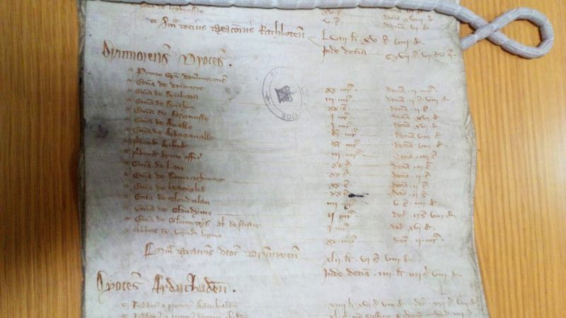
Researchers from Trinity have used papal assessments of ecclesiastical wealth during the reigns of Edward I and Edward II to shed new light on the economics, politics and culture of medieval Ireland.
Dr Chris Chevallier used parish incomes – largely based on tithing – as proxies for local wealth. The work puts an unprecedented level of focus on island-wide and regional trends from 1302-7 and shines a spotlight on the devastation caused by the Bruce Invasion of Ireland (1315-18) and the Great European Famine (c.1315-17).
The work also enables a comparison between changes in the 1302-7 values and the 1319-20 revaluations made in Munster and Leinster.

Collectively, the research forms Dr Chevallier’s PhD dissertation: Utilizing Papal Taxation Records for Geographical, Economic, and Cultural Analysis: A Study of Early Fourteenth Century Ireland. The work was based in Trinity’s Department of Geography and supervised by Dr Mark Hennessy.
The dissertation features over 50 maps that highlight different cultural regions and environmental features.

Dr Chevallier said:
The project is a comprehensive monograph of all this data. The final maps reflect efforts to provide accurate historical context and meet a high degree of scientific rigour. We now have a database that can illustrate multifaceted insights into medieval Ireland – even at the local level, for almost all the island.
Some of the major findings include:
- Dublin served as the economic heartland of the English colony, demonstrating high degrees of wealth as far west as Mullingar. However, there was a failure to control the Gaelic Midlands, northern Wexford, the Wicklow Mountains, and a considerable portion of the Leinster coastline. There is no data for the Dioceses of Ferns (Wexford), which is likely due to Gaelic and rebel pushback against lowland colonial settlements in the area
- Outside of the Dublin economic zone, Kilkenny, Lismore, and southeastern County Limerick were hotspots of wealth and population density within the colony. The maps substantiate CA Empey’s theory of a “Second Pale,” or a second bastion of colonial control largely based in southeast Ireland and northern Munster. Part of the Second Pale’s strength was the inclusion and adoption of Gaelic culture
- Environmental factors heavily influenced the shape of the colony. Colonial parishes correspond with almost surgical precision to terrain suitable for intensive agriculture. This terrain was characterised by lowland luvisols and cambisols with little slope and ideal drainage
- Independent Gaelic lordships were largely situated upon podzols, leptosols, and gleysols, as well as highlands or hilly terrain. This terrain was more suitable for pastoralism. Bogs, forests, and mountains provided safety against cattle raids and colonial intrigue, as well as military advantages against knights and infantry accustomed to fighting in ranks
- Inferences regarding political control, stability, and the dominant culture in an area can be made from the parish valuations, allowing additional degrees of precision to be added to political maps. Political maps from the study indicate that while colonial control in some regions was stronger and more resilient than expected, it was weakened by numerous internal frontiers and semi-independent Norman-Irish lords. It failed to truly control any province completely
Further Work
Dr Chevallier hopes to host the data on a digital GIS website, allowing the public and researchers to utilise the values. Until then, the project will be built on in other ways.
He added:
Although additional Irish valuations were likely destroyed in fires, my research indicates that there may be surviving transcripts made during the 19th Century. These could still be among archive miscellanea or private collections. There are, however, valuations and receipts for much of Europe that offer invaluable opportunities for mapping and analysis.”
“Outside of the maps of Ireland, I’ve been working on data for Bangor, Norwich, Besançon, Belley, and Lausanne. I’m particularly interested in how the Black Death and climate change impacted valuations.