New exhibitions spotlight 400 years of Ireland in maps
Posted on: 07 October 2025
Rare 16th century sea maps of Ireland, Cromwellian-era land surveys and 19th tourist maps feature in a new exhibition in the Old Library, Trinity College Dublin.
Entitled ‘The Island of Ireland in Maps’, the exhibition and accompanying online exhibition celebrate the extensive cartographic holdings of the Library of Trinity College Dublin in its Glucksman Map Library, with particular focus on maps from the 16th century to the mid 20th century.
“This is a wonderful opportunity to explore some of the beautiful and intriguing maps held in the Glucksman Map Library, which is dedicated to the care and consultation of over half a million maps. Some 150,000 of Trinity’s maps relate to Ireland, making it home to the largest printed map collection in Ireland,” the Librarian and College Archivist, Helen Shenton said.
The exhibitions include rare 16th century maps of Ireland developed by navigators exploring the Atlantic world, detailed land surveys undertaken as part of the Cromwellian conquest of Ireland as well as sea charts, atlases, relief models, aerial views, globes, and tourist maps.
Highlights from the two exhibitions include:
- The oldest map of Ireland in the Glucksman Library, a 1561 engraving of Ireland and Great Britain.
- A 1689 map detailing parishes, baronies and counties drawn from the Down Survey which mapped all the land to be confiscated and redistributed following the Cromwellian conquest.
- A 1611 coloured map of Leinster which includes an inset containing the earliest surviving plan of Dublin.
- An 1839 geological map across six large sheets originally made for planning the railway network in Ireland.
- A foldable pocket-size map of Dublin Ordnance Survey produced in 1902-1906 was designed to meet the growth of the tourist and leisure market.
- An Irish-language school atlas of Ireland dating from 1948 with placenames written in Gaelic script.
-REDUCED-A-350X439.png) Map Librarian Paul Ferguson, curator of the exhibition, explains: “The first printed maps of Ireland were developed by navigators and traders operating in what they understood at the edge of the Atlantic world. Later maps were compiled by surveyors as part of the confiscation and transfer of land from Irish landowners to English and Scottish settlers. Completed just before the Great Irish Famine, the first Ordnance Survey mapped the landscape in amazing detail”.
Map Librarian Paul Ferguson, curator of the exhibition, explains: “The first printed maps of Ireland were developed by navigators and traders operating in what they understood at the edge of the Atlantic world. Later maps were compiled by surveyors as part of the confiscation and transfer of land from Irish landowners to English and Scottish settlers. Completed just before the Great Irish Famine, the first Ordnance Survey mapped the landscape in amazing detail”.
As a legal deposit library for Ireland the Glucksman Library continues to receive approx. 900 new map titles annually. Its collections are an important resource for students, researchers, and professionals, as well as local and family historians.
The physical exhibition is on display in the Long Room of the Old Library and runs until early February 2026. It forms part of the Book of Kells Experience. See here to book tickets. The online exhibitions can be viewed on the Library’s website.
Images:
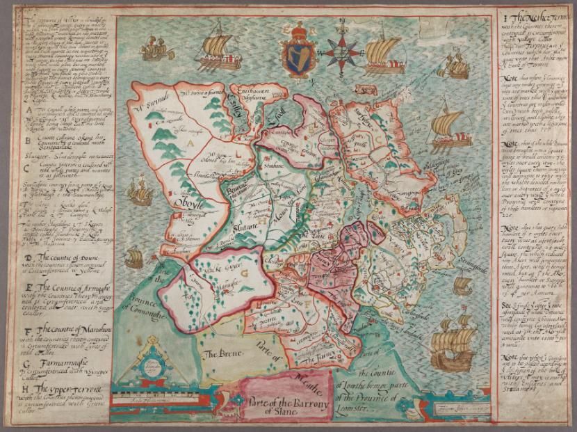
1. A map of the Ulster counties / Francis Jobson. [c.1598].
2. A general map of Ireland to accompany the Report of the Railway Commissioners. Dublin: Ordnance Survey, 1839.