

Coastal flooding and climate change: what can we do about it?
 Professor Iris Möller, Head of Trinity College Dublin’s Department of Geography, states that this relates to “coastal geomorphology”: how physical and biological processes interact at the coast. Professor Möller is interested in the effects of the landscape and physical environment on how people behave and interact with their environment, and how this is predicted to change in the coming years.
Having recently joined Trinity from the University of Cambridge, Professor Möller works on an interdisciplinary basis with other researchers in various fields, as well as with external collaborators. Her research addresses what is called “coastal morphodynamics”, which she describes as the link between coastal landforms (such as cliffs and headlands) and the processes that shape them.
While at Cambridge, she was conducting research into coastal change and salt marshes, as shown in this clip. She continues this research now that she has moved to Trinity, and seeks to apply her knowledge to Irish contexts. She and her team are frequently approached by local governments and engineering companies who, she says, “now do a lot of the consulting for governments in terms of how we should manage particular areas of the coast.” She has also been contacted by national government organisations such as the Environment Agency in the UK and has been contributing to discussions hosted by the Environmental Protection Agency in Ireland, who seek to “draw on our knowledge in order to make decisions” about planning for sea level rise and the “way in which the coast is likely to change.”
Professor Möller spoke about her experience on the TriPod podcast, hosted by Dr John Whelan, Information and Communications Technology Manager at Trinity Research and Innovation, and Edward O’Loughlin from the Trinity Business School. Speaking about her early interest in the area, she was fascinated by the idea that “humans can alter their environment to such a degree that the very humans who depend on that environment then suffer from that alteration.”
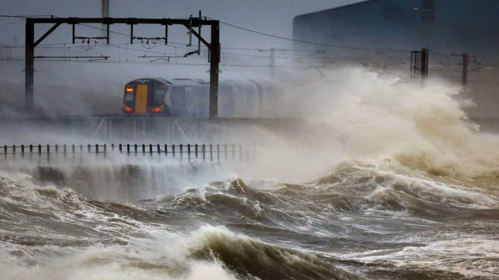
In the face of a worsening climate change emergency, Professor Möller uses her expertise in this field to provide guidance on how communities can potentially adapt to a changed environmental future. Sea levels will continue to rise and severe storms will become progressively more frequent. The Irish Times, in another article, reports that “Ireland’s east coast, south west and western seaboard is vulnerable in an extreme scenario where sea level rise and a storm episode combine. The highest level of extreme episodic sea level rise – 5m to 9m – is predicted for the northwest and east of England, south Wales, northwest France and northern Germany.”
In fact, Professor Möller has been working as an academic consultant with local governments and communities on the east coast of England on a pilot project entitled Coastal Dynamics Monitor, or “CoDyMon”. In this project, which is described as “a service to monitor large-scale adaptation schemes for climate change and sea level rise,” Professor Möller’s expert knowledge on how the coast is likely to respond to climate change is used alongside satellite remote sensing with the goal of alleviating coastal flooding and erosion.
Local governments, Professor Möller says, are “at the coalface” of this struggle with climate change, but are also subject to the policies being developed and the calls being made at a national level where more short-term political biases may come into the picture. According to Professor Möller, “when it comes to sea level rise and climate change, there is a long lead time, as our actions of the past and the present have lagged consequences for decades.”
The CoDyMon project she worked on posits that coastal zones are “increasingly exposed to human exploitation,” as well as environmental changes due to “climate change, and sea level rise, increased erosion and flood risk.” There is also the risk of the loss of ecosystem services, such as those provided by salt marshes or dunes. Any coastal landform provides a valuable resource as “a first line of defence against storm surge waves, reducing storm water levels and the run up of waves on landward sea defences.” The CoDyMon project looked at “sandscaping” and “sand engines”, which involves “artificially created sandbars and dunes” and taps into how the “waves, wind and currents move the sand over time, reducing erosion elsewhere.”
To do this, Professor Möller partnered with Specto Natura and Geoger, two consultancy companies with expertise in satellite remote sensing and image processing. They use Earth Observation techniques – satellites, in this instance – to provide accurate and reliable information about the environment. Several regional local governments banded together around the English east-coast to develop risk-reducing measures, and Professor Möller worked with them and the project team, to provide guidance on this sandscaping and sound engines, to combat coastal erosion and flooding.
Local governments often lack funding and resources to monitor the changes in the sand over time, and it can be difficult to survey an area after a storm when it may be unsafe to access. Using the satellites, data can be gathered on this, solving many of the barriers to the effective monitoring of the coastal zone by local governments. The satellites keep track of changes that have occurred on the surface with 3D maps of the beaches allowing areas of sand loss to be spotted early. This can help local governments to plan ahead for the effectiveness of the sand dump as a natural buffer.
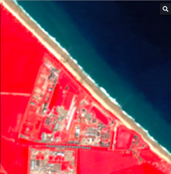
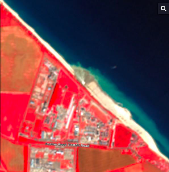
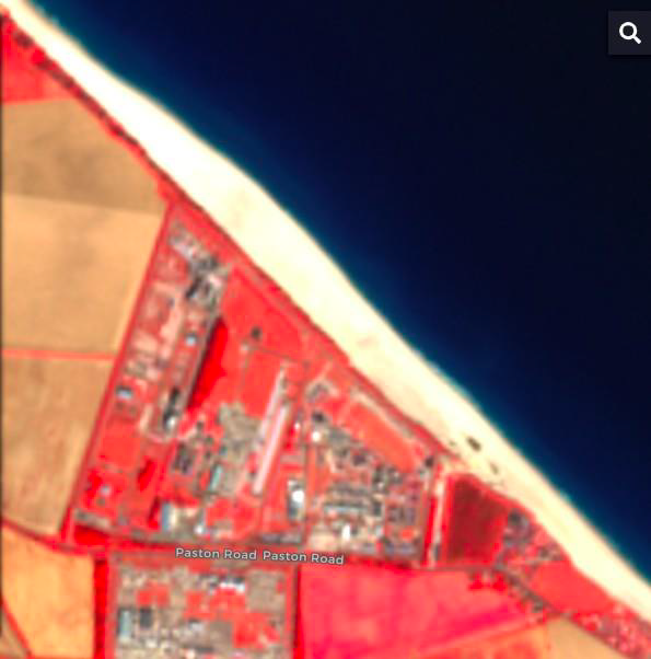
According to Professor Möller, this type of collaboration has the best chance of resulting in the development of new, sustainable coastal protection schemes. Below are images gathered by the European Union’s Copernicus programme, displayed to emphasise vegetation (red), bare sediment (white) and water (dark blue), and showing details down to 10 m. From left to right, it shows the changes in the sand over time: From 3rd July, 23rd July, and 25 August 2019.
Using these techniques, the research explores how the sand on the coast is deposited in response to tidal movements – the “sand dump” – and possible ways this sand can be used as a natural buffer for the impacts of storms, which borrows time for the local community.
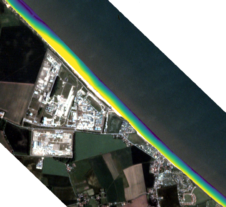 The results (pcitured right), based on 3 m spatial resolution images from Planet (the largest commercial EO satellite operator) show beach morphology after the creation of artificial sand dunes, or sandscaping. Yellow is high elevation, blue is low elevation, highlighting the potential for increased protection for the coast against the effects of flooding and erosion.
Professor Möller states that this consultancy project was a “prototype,” which has been successful. Applying one’s expertise outside of academia, she says, “makes you feel your research has a purpose.” She refers to the “academia triangle” of research, teaching, and external or applied work. The immediate impact, she points out, is on the people she teaches. And the applied work is conducted using research and teaching. In her experience, applied work “almost always has some synergy with teaching,” and undergraduate and postgraduate students benefit from these connections through gaining placements, internships, or jobs, so the client also benefits.
Working with Trinity Research and Innovation is beneficial, she says, because there are pre-existing relationships with external charities, government bodies or companies, and from there they can “spark the conversation. Trinity is unique in providing such strong support for this.”
**Satellite images courtesy of Planet and the European Union Copernicus programme.
Listen to Iris talking about climate change on our podcast!
Article by Dr Kate Smyth, Consultancy Development Officer, CONSULT Trinity, Trinity Research and Innovation.
For more information on academic consultancy visit CONSULT Trinity
Find out more about writing for researchMATTERS here.